Anchorages and coves in Alicante are what separate an ordinary boat trip from a memorable one. Knowing where to drop the anchor, what kind of bottom you have below and where the wind is coming from is what makes the difference between a perfect day and going back to port with a tangled chain or a group made uncomfortable by the rolling.
This guide is practical and local. It covers the main anchorages accessible from the port of Alicante in a regular sailing day: Postiguet, Cabo de las Huertas, Almadraba, San Juan and the island of Tabarca, plus a handful of options a short hop to the north or south. No prices, no commercial recommendations: just what you will find at each spot, what kind of seabed it has, how it behaves with each wind, and what to check before letting out chain.
Sources and safety note
Last reviewed: 28 June 2026. This guide is local planning guidance, not a navigation chart or legal permission to anchor. Before choosing a spot, check the AEMET marine forecast, Puertos del Estado PORTUS data and official protected-area information for Tabarca and posidonia. Final anchoring decisions depend on the skipper, the chart, the sounder, visible seabed, traffic and any current restrictions.
What an anchorage is and why choosing the right one matters
An anchorage is an area where a boat can stay still secured to the seabed by its own anchor, outside the harbour. It is not the same as a mooring: here you depend on the weight of the anchor, the length of chain you let out (scope) and the holding of the bottom. On the Costa Blanca, bottom types change a lot within just a few miles — from ideal fine sand to posidonia meadows (a protected marine plant that must not be damaged), to rock and shingle where the anchor may or may not set well.
Choosing the right anchorage matters for three reasons. First, safety: if the wind shifts and your anchor drags, you can end up on another boat or on the shore. Second, comfort: a cove exposed to easterly winds on a June afternoon will roll enough to ruin lunch on board. Third, respecting the ecosystem: anchoring on posidonia is forbidden in protected areas and, even outside them, it remains bad practice that Alicante's nautical sector now takes seriously.
The good news is that the Bay of Alicante offers fairly benign conditions for most of the year, with several anchorages roughly 20-45 minutes of navigation in normal conditions from the marina of the Real Club de Regatas, where we keep the sailing yacht Peggy berthed. That makes it possible to string together two or three spots in a single day if the wind plays along.
How to read an anchorage before dropping the anchor
Before letting chain out, it is worth doing a quick reading of four variables. Any skipper with local experience does it almost without thinking, but it is useful to understand if you plan to sail the area or simply care about the context.
- Depth: most anchorages in the Bay of Alicante work between 4 and 12 metres. Below 3 metres the risk of touching bottom with the keel during a roll is real; above 15 metres you need a lot of scope (the usual ratio is 5:1 over depth).
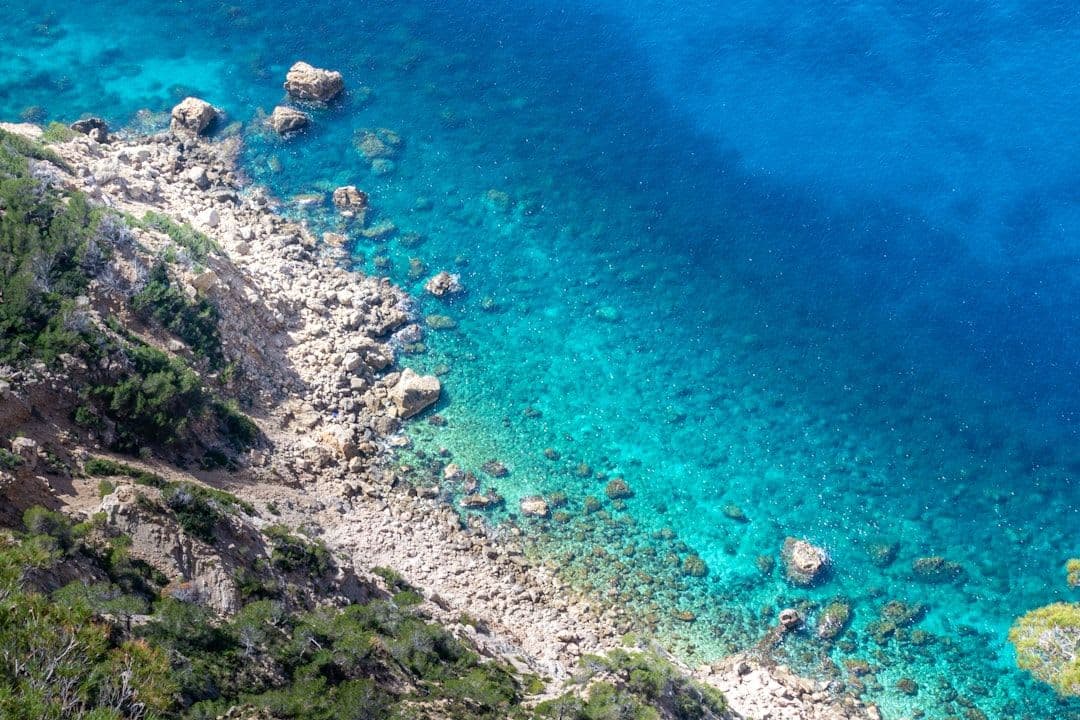
- Type of bottom: sand (the easiest to read; it shows almost white on the sounder and looks bright from the deck when the water is clean), posidonia (a dark green-brown patch, do NOT anchor on it), rock (risk of fouling the anchor) and shingle (uneven holding).
- Wind shelter: Alicante is dominated by two regimes. In summer, the southeast thermal (it builds mid-afternoon, can build in the afternoon and ease near dusk). In winter and spring, easterly levante (long, with swell) and, occasionally, lebeche from the southwest. Each cove shelters well or poorly depending on its orientation.
- Traffic and zoning: there are zones marked with yellow buoys (off-limits to boats) in front of beaches such as Postiguet and San Juan, especially in high season. They must be respected.
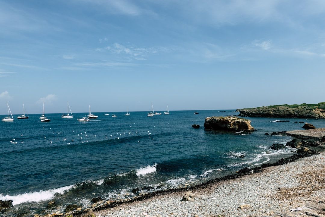
The Bay of Alicante: Postiguet and the urban shore
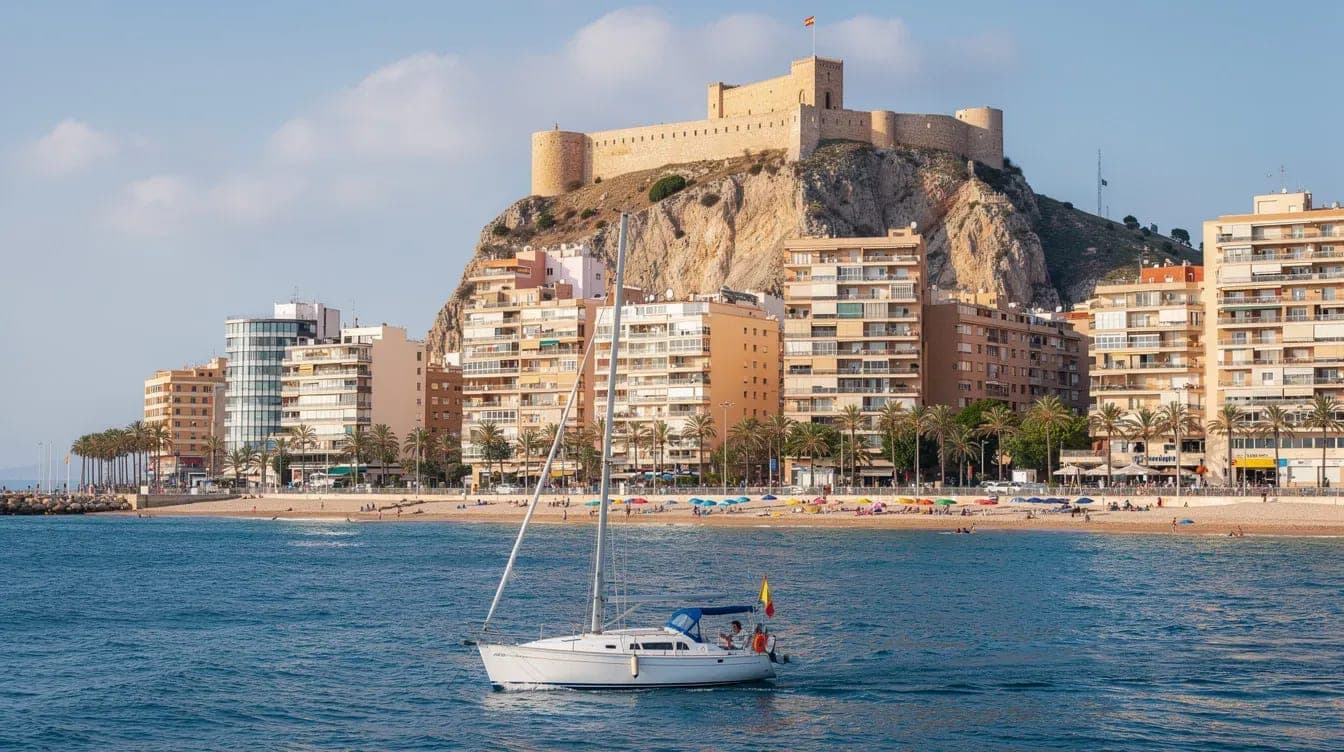
The closest option to the marina. Leave the RCRA and, after a short hop from the marina to the southeast, you are already at the northern end of Postiguet beach, right under Monte Benacantil with the Santa Bárbara Castle as a backdrop. It is an urban anchorage: the noise of the seafront promenade carries, the water has more small-boat traffic, and the view compensates for what the spot lacks in wildness.
- Useful depth: a practical working depth outside the beach buoy line, to be checked on the sounder and chart.
- Bottom: mostly sand, with occasional posidonia patches you want to avoid.
- Shelter: good against westerly and southwesterly winds; exposed to easterlies (the sea rolls straight in).
- Who it suits: short outings, a first anchorage in a longer day, a quick swim before heading on to Cabo Huertas.
North of Postiguet, off Cap de l'Horta (Cabo de la Huerta), is where the truly interesting area begins.
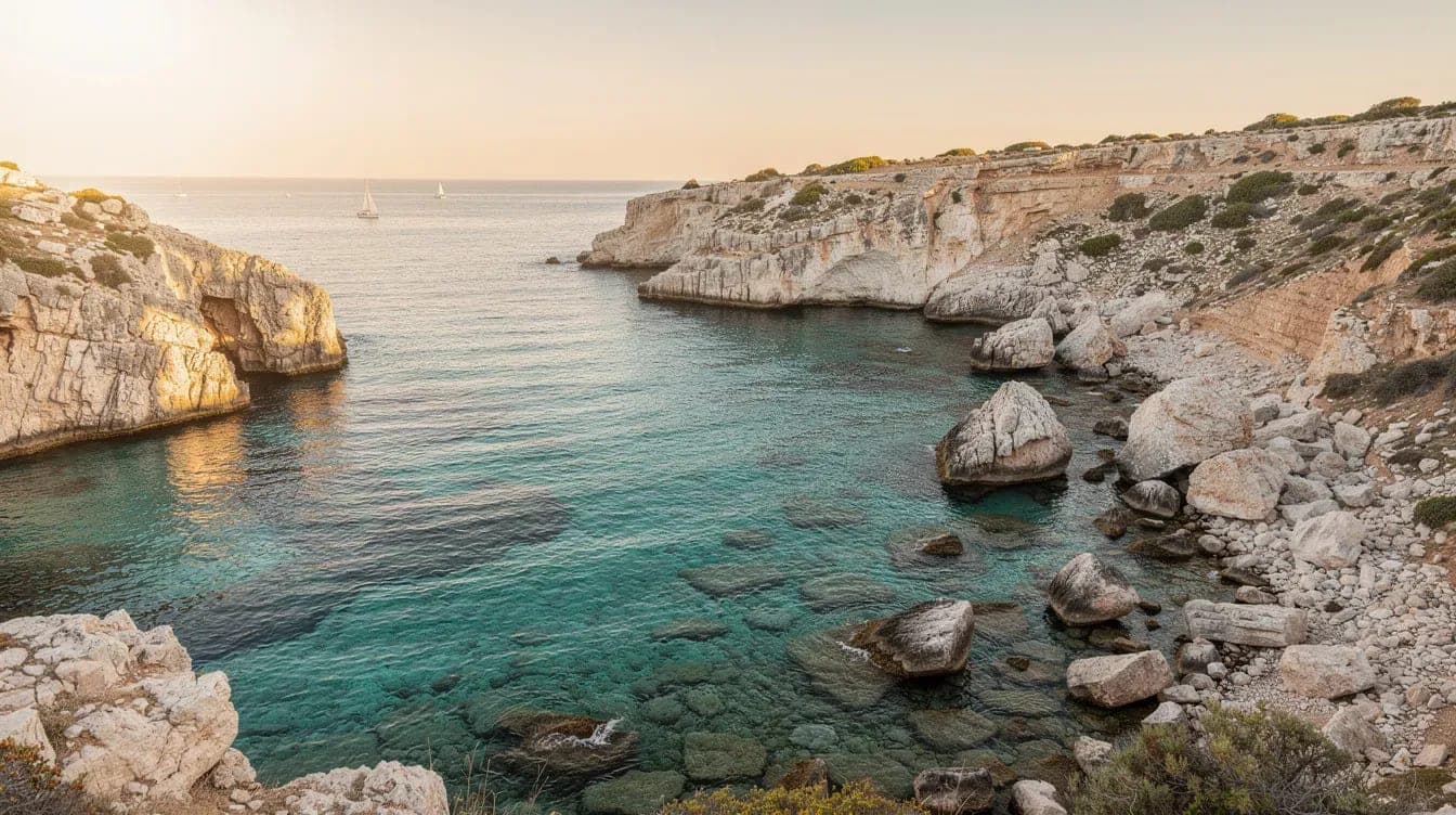
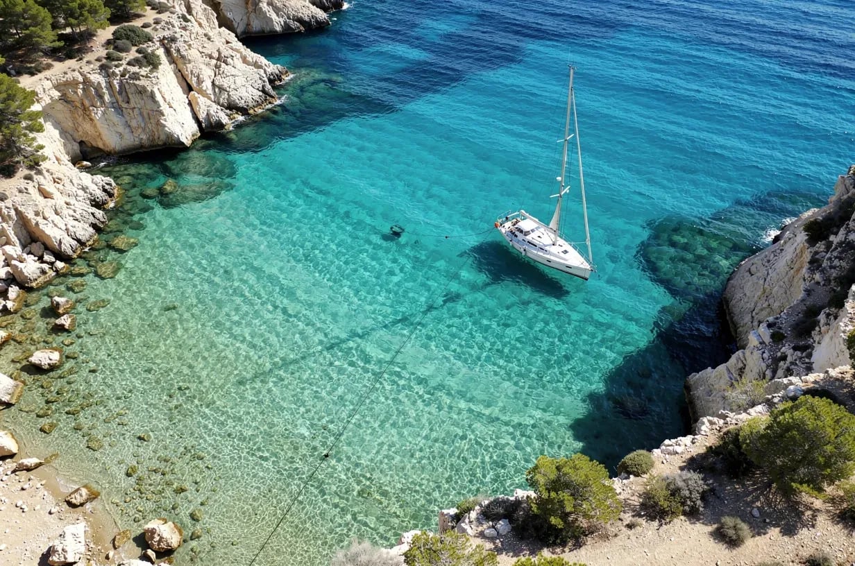
Cabo de las Huertas: Almadraba, Cantal and hidden coves
Cabo de las Huertas is probably the stretch of coast richest in small anchorages within Alicante city's reach. A string of short coves with clear sandy bottoms, transparent water and just enough room for one or two boats. In high season they fill up quickly, especially on weekends and bank holidays.
- Cala de la Almadraba: the most well known of the cape. Sandy bottom with a few patches of posidonia towards the middle of the cove (visible as darker shapes from the deck). Depth varies by exact position; check the chart, sounder and visible bottom before dropping. Decent shelter against easterly winds in the southern half, exposed to the afternoon thermal.
- Cala Cantal: smaller, popular with divers. Mixed sand-and-rock bottom; the anchor can foul on the rocks, so it pays to look for a clear patch before dropping.
- Cala Palmera and smaller coves: just enough room for a single well-anchored boat. Good for a technical stop if the easterly wind eases off.
The cape has the added advantage of being a short coastal run from the port, which makes it the natural destination for half-day outings. If you want to go deeper into the specific coves of the area (including options further north all the way to Calpe and Jávea), this guide to the best coves near Alicante by sailing yacht goes into detail.
Playa de San Juan: open space and sand
Past the cape, opening northeast, lies San Juan beach: kilometres of sand that end in the municipality of El Campello. A wide, easy, predictable anchorage that makes a good option for boats new to the area or for groups looking for calm water without complications.
- Bottom: bright sand for practically its entire length. It is one of the few spots where the anchor holds "by the book".
- Depth: starting from the beach buoy line (300-400 metres offshore in mid-summer), between 6 and 10 metres without much complication.
- Shelter: very good against westerlies and southwesterlies. Against easterlies a choppy swell can roll in, especially in autumn.
- Who it suits: a long picnic, paddle surf and gentle snorkelling. If snorkelling is your thing, there are snorkelling routes from a boat in Alicante that cover the area in detail.
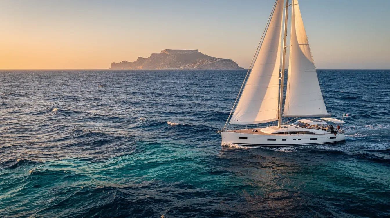
Tabarca: the jewel with its own rules
About 10-12 nautical miles south of Alicante (60-90 minutes of navigation depending on wind) lies Tabarca island, the only inhabited island in the Valencian Community and, above all, a marine reserve since 1986. It is the most spectacular anchorage in the area, but also the most regulated.
- Zoning: the reserve has areas with varying levels of protection. Anchoring is only allowed in specific zones (mainly the north side of the island, and always outside posidonia meadows). In high season there are ecological mooring buoys for free use, occupied on a first-come-first-served basis.
- Bottom: sand in authorised zones; abundant posidonia around them (no anchoring). The sounder and visual reading of the water are particularly important here.
- Shelter: the island lies east-west, so it shelters well from easterlies on its north side and from westerlies on its south side, depending on the day's wind. With a strong lebeche, the crossing from Alicante can be tough and the route may need rethinking.
- How it fits a day out: Tabarca needs at least a full day. For groups visiting for the first time, there is a detailed guide to the one-day excursion to Tabarca and another on what to do on the island that is worth reading first.
Further north: El Campello, Villajoyosa and the waters of Benidorm
If you decide to head north, there are three stretches worth knowing. El Campello offers the Cala del Amerador and the area around Cap Negret — small coves with mixed bottoms and slightly cooler water than inside the bay. Villajoyosa has its own range of short anchorages off the colourful town centre, though water quality drops compared to Cabo de las Huertas. Benidorm, with its iconic island, is already a destination for a full day or multi-day trip.
These options usually come into play when the wind is from a southerly or southwesterly quarter and the best holding is found in waters further north. A local skipper adjusts the route to the day's actual forecast, not to yesterday's ideal plan.
Further south: Santa Pola and the other side of Tabarca
To the south, Santa Pola is the alternative departure for Tabarca: the crossing is shorter (about 4-5 miles), although most of the professional charter activity sails from Alicante. Off Cabo de Santa Pola, under the lighthouse, there are a few coves with reasonable anchoring, exposed to easterly winds. The south side of Tabarca, already within the reserve, is more restricted.
If you are after a boat trip without obsessing about reaching Tabarca, this overview of types and formats of boat trips in Alicante helps to understand what fits each kind of day (half-day, full-day, sunset).
Practical tips before dropping the anchor
Five pointers an experienced skipper checks almost without thinking and that are worth keeping in mind if you sail the area:
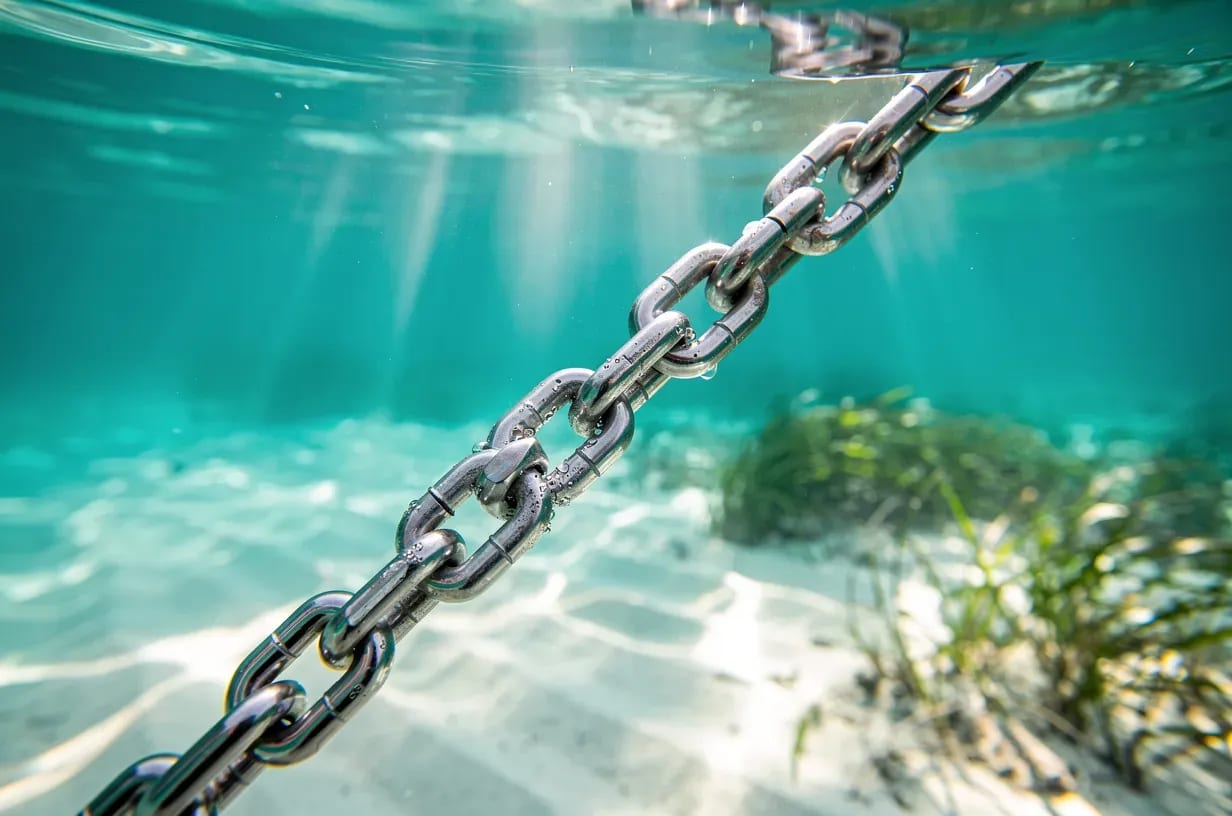
- Look at the sounder and the colour of the water before letting go: if the patch under the boat looks dark, there is almost certainly posidonia. Move a few metres until you find a clear patch before dropping.
- Enough scope: a practical rule is to let out chain in a 5:1 ratio over the actual depth, more if there is wind or sea. Too little scope means an anchor that drags.
- Back down gently to test: once the chain is taut, give moderate astern power for 10-15 seconds. If the boat does not move, the anchor is set. If it moves, lift and try again.
- Respect the yellow beach buoys: inside the marked area you cannot anchor or motor. Real fines and, more importantly, a real risk of an incident with swimmers.
- Check the forecast before deciding the destination: the difference between a great day and a broken day on the Costa Blanca almost always comes down to having read the afternoon wind well. AEMET and Windy are the two standard references.
Anchorages and coves in Alicante work as a network: there is no single spot that suits every wind and every afternoon. The beauty of sailing this bay is precisely that flexibility — you leave the port with a plan, you look at the actual wind once you are out, and you decide whether to head for the cape, for San Juan or for Tabarca with the information at hand. That reading of the day is what turns a decent outing into one people remember years later.
Fact-check and operational sources
Anchorages depend on wind, swell, seasonal buoyage and environmental restrictions. Before choosing a route, check the AEMET maritime forecast for Valencia and Murcia and wave/wind data from Puertos del Estado - PORTUS. For Tabarca, use the official MITECO material on the Tabarca marine reserve as a reference and never anchor on posidonia. The skipper makes the final anchoring decision based on actual conditions.